Update: Monday 31 August 2026
Public exhibition of the Gladesville Masterplan Planning Proposal and draft Development Control Plan (DCP) was undertaken between 11 March and 24 April 2026 and the Final Outcomes Report, Council report and recommendations were presented at the Extraordinary meeting of Council on 6 July 2026. These reports are available here:
Update: Council Meeting Resolution 6 July 2026At the Extraordinary Meeting on 6 July 2026, Council resolved to:
- Receive and note the Submissions Outcome Report included as Attachment 1 to this report.
- Note feedback received from the community as part of the public exhibition of the Gladesville Masterplan Planning Proposal and Development Control Plan and thank all in the community who participated in the consultation process.
- Forward the Planning Proposal included as Attachment 2 of this report to the NSW Department of Planning, Housing and Infrastructure, and request that the NSW Minister for Planning and Public Spaces (as the applicable local plan making authority) make a local environmental plan to give effect to the Planning Proposal.
- Adopt Chapter 4.4 of the Hunters Hill Consolidated Development Control Plan, included as Attachment 3 of this report, and make necessary arrangements to implement this Plan.
- Delegate authority to the General Manager to make amendments to the Planning Proposal included as Attachment 2 of this report and Development Control Plan included as Attachment 3 of this report that:
- Are minor and do not alter the intent; or
- Are required by the Department of Planning, Housing and Infrastructure in order to facilitate making of the Local Environmental Plan referenced within Item (C).
- Notes the potential opportunity to further investigate whether a site-specific local provision could be prepared to encourage the coordinated redevelopment of the Massey Street transition area with the Gladesville Village Site, subject to appropriate public benefit, urban design, access, open space and infrastructure outcomes.
- Authorises the General Manager, or delegate, to consult with the Department of Planning, Housing and Infrastructure and Council’s legal advisers on the feasibility, form and procedural requirements of any such provision.
- Notes that this further investigation does not amend, replace or delay the Planning Proposal for the Gladesville Village Site presently before Council.
- Council is to undertake the following studies and report back to council within 6 months:
- As part of the general DCP review already underway:
- adopting lower parking rates in the Gladesville Town Centre and LMR areas to minimise additional traffic congestion, having regard for the studies and recommendations undertaken for this planning proposal;
- extending design excellence requirements for the key site to all buildings of a certain size or type (eg: apartment blocks in the LMR reform areas, or buildings over 3 storeys).
- The potential for a residential parking scheme within 100m of the key site to reduce spillover effects of parking as recommended in the studies undertaken for this planning proposal,
- Public domain improvements as recommended by SCP (p12) particularly:
- Converting Massey Lane to a shared zone; and
- Safe crossing facilities to Cowell Street.
- Council is to investigate, and if determined appropriate, amend (under the delegation granted in item 5 of the motion) the Development Control Plan to:
- in 3.1.2 South Gladesville Precinct “green gateway” recognise the existing neighbourhood centre on Victoria Road between Manning Street and Sunnyside Street, which is over 500m from the main centre and has its own role in supporting residential growth and supporting walkability.
- in Figure 5 in 4.1 provide active frontage corners on Hillcrest Street and Junction Street, in recognition of both the existing active frontages and complementary uses on the Ryde LGA side of the street.
- in 4.2 (d) increase the floor-to-ceiling height of a small shop to 3.3m consistent with section 4C of the Apartment Design Guide, or 3.6m consistent with 4.2(c).
- in 4.2.2 recognise in interfaces the current residential heights permitted by the LMR reforms, with words to the effect of “(a) a deep soil setback of 3m and (b) a setback of 12m above the permitted building height of that residential zone in accordance with the LEP or Chapter 6 of the Housing SEPP (whichever is higher)” and amend clause 6.1.5 Secondary Setbacks to be consistent with this (noting it is currently inconsistent with the current 4.2.2).
- consider whether section 4 particularly 4.2.3 meets the deep soil recommendations and tree canopy requirements of DPHI, particularly the minimum 3m connected to 6m deep contiguous deep soil and 15% deep soil area (plus a requirement to plant 1 medium tree per 300sqm of site area) in the Urban Tree Canopy Targets and Development Controls Report by Gallagher Studio and Studio Zanardo, 2021
- exclude solid facades in 4.3(j) from shopfronts and insert a new clause to address shopfronts, to avoid inconsistency with 4.1. In doing so consider whether 4.3(m) word “shopfronts” should read “facades”
- amend 5.2(c) to distinguish between through-building links and through site links open to the sky. Through-site links open to the sky are typically 6m wide, the narrowest Scotch Row (Barangaroo) is 5m wide. Through-building links typically have a height requirement of 2 storeys or 1.5x the width, or 6m. Cross referencing with 6.1.8 would also assist this clause.
- amend 5.4 to require paving treatments to include vehicle crossovers consistent with the Design of Roads and Streets Manual
- amend 6.1.7 Open Space Network to require a minimum width to the key open space areas, to avoid unintended outcomes like a 6m wide “open space” shared zone being delivered on Massey Street.
- amend 6.1.6 to provide guidance on the depth of active use, and the proportion of retail and non-retail use at surface level under 6.1.9 - noting for example that The Canopy development specified a minimum 925sqm of surface level retail for this purpose.
- amend 6.1.15 overshadowing of Gladesville Public School to consider activities from 7am as per Ryde Council’s submission
Background
The Gladesville Masterplan Project currently involves a review of planning rules that apply to the Gladesville Village Centre. The Centre includes existing ‘mixed use’ zoned land generally between Pittwater Road in the north, Gladesville Police Station in the south, Flagstaff Street in the east and Victoria Road in the west, as shown within Figure 1 below.
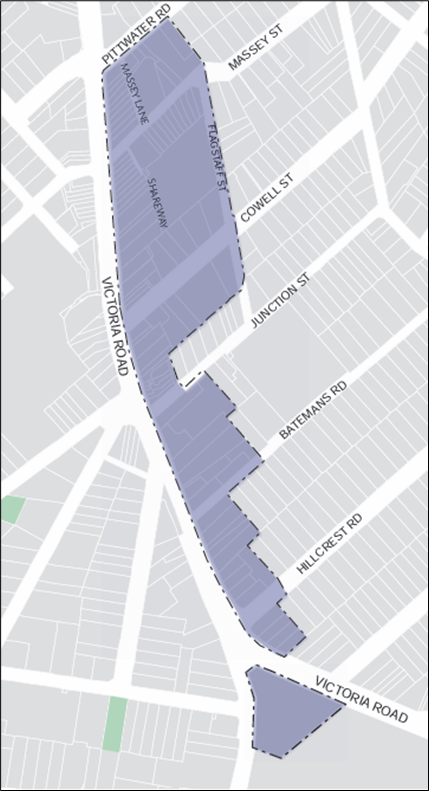
Figure 1 - Project area
Project documents which are currently on public exhibition consist of two main parts, being a Planning Proposal (PP) and Development Control Plan (DCP). The PP, which would change planning controls within the Hunters Hill Local Environmental Plan, applies to the locality of Gladesville Shopping Village, within the area shown in Figure 2.
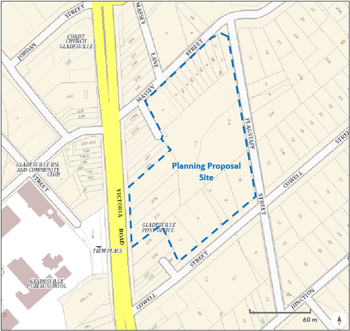
Figure 2 - Planning Proposal site
This PP seeks to:
- Achieve renewal of the Gladesville Village Centre, incorporating:
- Well designed buildings,
- Increased publicly accessible open space,
- A new supermarket with associated retail services,
- A vibrant night-economy,
- Improved pedestrian connectivity; and
- Increased community facilities.
- Deliver new and well located housing opportunities within the Gladesville Village Centre.
Key features of the PP include:
- Increased building height and density to facilitate renewal.
- Two new publicly accessible open space areas.
- A through site link connecting the public open spaces to Victoria Road, Massey Street and Cowell Street.
- At least 5,000 square metres of gross floor area used for the purposes of retail, including at least 3,500 square metres for the purposes of a supermarket.
It is also intended that existing residential properties fronting Massey Street would be rezoned from mixed use to residential. This is intended to allow this area to benefit from increased height (of up to six stories) and increased building density under recent NSW Government Housing Policy changes. This would facilitate improved building height transition between the 19 story buildings within the key site, and adjoining residential areas, where recent NSW Government Housing Policy changes also apply.
Key intended outcomes of the PP, including buildings of up to 70 metres (19 stories) and improved open space and pedestrian connections are indicatively illustrated within Figures 3 and 4 below.
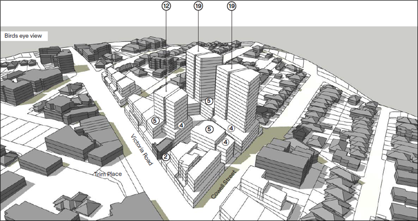
Figure 3: Indicative building heights associated with the PP site
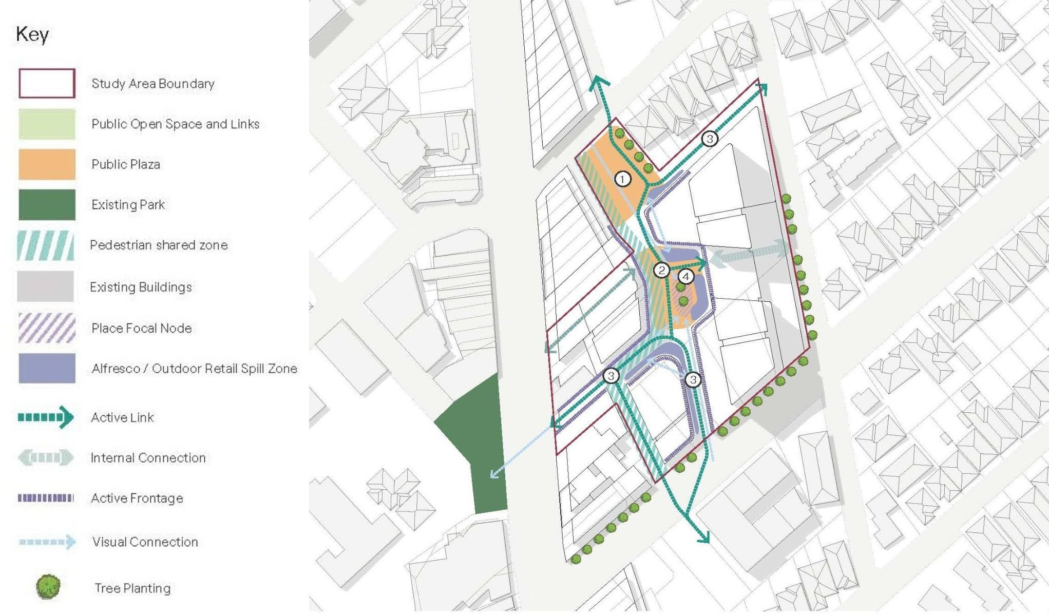
Figure 4: Indicative open space configuration
In addition to the PP, the DCP (which applies to most land shown in Figure 1) addresses aspects such as public domain, building, heritage conservation and transport development outcomes for the entire Centre.
The character objectives for development in the Centre from the DCP are:
GREEN
‘Green’ is defined by the community as a significant increase in the amount of vegetation in the Centre: vegetation that reflects community environmental values and the garden style landscaping of the surrounding residential neighbourhoods. Greenery should be used to soften buildings, street edges, provide shade for people and a buffer to vehicular traffic. |
ENGAGING
For the community, ‘engaging’ captures the desire for an exciting, interactive and pleasant street level experience that incorporates warm, natural materials such as timber, brick and sandstone; user-friendly paths; respect for heritage; heritage interpretation; and artistic elements. |
SOCIAL
‘Social’ reflects the community’s aspirations for places encouraging people to stay, including public seating areas, outdoor dining, informal landscape design and a relaxed and safe environment suitable for all ages. |
The DCP also includes a number of development priorities. Development priority illustrations from the DCP are shown below.
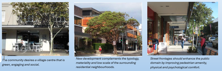
Figure 5: Development Priority Illustrations from the DCP
Why are we doing this?
The Project is in response to community sentiment about the poor presentation of the village centre, variable trading performance and delayed renewal of properties. It has been made clear to Council that the renewal of the Gladesville Village Centre is important for local residents. Feedback to Council has indicated that the community would like to see well-designed buildings, increased public open space and a new supermarket with associated retail. The community is also keen to see a vibrant night-economy, improved pedestrian connectivity and increased community facilities. The Project seeks to achieve the communities’ aspirations with regard to the renewal of the Gladesville Village Centre.
How were proposed changes to planning rules identified?
The PP and DCP which are currently on exhibition consider and consolidate:
- Information from the existing DCP applying to the Centre, adopted in 2015.
- Feedback received following community consultation on the Gladesville Masterplan, undertaken in 2021.
- Recent additional technical work required by the NSW Government to inform and progress the Project, including heritage, contaminated land, economic and transport assessment.
The above have informed master planning and the proposed updated planning controls.
While the entire Project area shown in Figure 1 has been considered as part of the Project, renewing the Centre, and at the same time conserving character and heritage is a balance. Not all areas of the Centre were identified as suitable and viable for increased development, due to considerations such as development constraints (e.g. lot size and configuration), and potential unacceptable impacts on heritage, character and the presentation and function of the Centre.
Changes that have been proposed seek to facilitate viable renewal of the Centre, whilst also minimising impacts to aspects such as heritage and character.
What is the process and timeframe for these proposed changes?
The current stage of the Project involves public exhibition of the PP and DCP, to allow the community to review the proposal and to provide feedback to Council.
Following public exhibition, Council will consider all community feedback, and make a decision to proceed with the proposal, to amend the proposal, or not to proceed.
This process is proposed to be finalised by late 2026.
Community Consultation
The public exhibition of the proposed changes to the Local Environmental Plan and Development Control Plan took place from 11 March to 24 April 2026.
Update: Monday 31 August 2026
Public exhibition of the Gladesville Masterplan Planning Proposal and draft Development Control Plan (DCP) was undertaken between 11 March and 24 April 2026 and the Final Outcomes Report, Council report and recommendations were presented at the Extraordinary meeting of Council on 6 July 2026. These reports are available here:
Update: Council Meeting Resolution 6 July 2026At the Extraordinary Meeting on 6 July 2026, Council resolved to:
- Receive and note the Submissions Outcome Report included as Attachment 1 to this report.
- Note feedback received from the community as part of the public exhibition of the Gladesville Masterplan Planning Proposal and Development Control Plan and thank all in the community who participated in the consultation process.
- Forward the Planning Proposal included as Attachment 2 of this report to the NSW Department of Planning, Housing and Infrastructure, and request that the NSW Minister for Planning and Public Spaces (as the applicable local plan making authority) make a local environmental plan to give effect to the Planning Proposal.
- Adopt Chapter 4.4 of the Hunters Hill Consolidated Development Control Plan, included as Attachment 3 of this report, and make necessary arrangements to implement this Plan.
- Delegate authority to the General Manager to make amendments to the Planning Proposal included as Attachment 2 of this report and Development Control Plan included as Attachment 3 of this report that:
- Are minor and do not alter the intent; or
- Are required by the Department of Planning, Housing and Infrastructure in order to facilitate making of the Local Environmental Plan referenced within Item (C).
- Notes the potential opportunity to further investigate whether a site-specific local provision could be prepared to encourage the coordinated redevelopment of the Massey Street transition area with the Gladesville Village Site, subject to appropriate public benefit, urban design, access, open space and infrastructure outcomes.
- Authorises the General Manager, or delegate, to consult with the Department of Planning, Housing and Infrastructure and Council’s legal advisers on the feasibility, form and procedural requirements of any such provision.
- Notes that this further investigation does not amend, replace or delay the Planning Proposal for the Gladesville Village Site presently before Council.
- Council is to undertake the following studies and report back to council within 6 months:
- As part of the general DCP review already underway:
- adopting lower parking rates in the Gladesville Town Centre and LMR areas to minimise additional traffic congestion, having regard for the studies and recommendations undertaken for this planning proposal;
- extending design excellence requirements for the key site to all buildings of a certain size or type (eg: apartment blocks in the LMR reform areas, or buildings over 3 storeys).
- The potential for a residential parking scheme within 100m of the key site to reduce spillover effects of parking as recommended in the studies undertaken for this planning proposal,
- Public domain improvements as recommended by SCP (p12) particularly:
- Converting Massey Lane to a shared zone; and
- Safe crossing facilities to Cowell Street.
- Council is to investigate, and if determined appropriate, amend (under the delegation granted in item 5 of the motion) the Development Control Plan to:
- in 3.1.2 South Gladesville Precinct “green gateway” recognise the existing neighbourhood centre on Victoria Road between Manning Street and Sunnyside Street, which is over 500m from the main centre and has its own role in supporting residential growth and supporting walkability.
- in Figure 5 in 4.1 provide active frontage corners on Hillcrest Street and Junction Street, in recognition of both the existing active frontages and complementary uses on the Ryde LGA side of the street.
- in 4.2 (d) increase the floor-to-ceiling height of a small shop to 3.3m consistent with section 4C of the Apartment Design Guide, or 3.6m consistent with 4.2(c).
- in 4.2.2 recognise in interfaces the current residential heights permitted by the LMR reforms, with words to the effect of “(a) a deep soil setback of 3m and (b) a setback of 12m above the permitted building height of that residential zone in accordance with the LEP or Chapter 6 of the Housing SEPP (whichever is higher)” and amend clause 6.1.5 Secondary Setbacks to be consistent with this (noting it is currently inconsistent with the current 4.2.2).
- consider whether section 4 particularly 4.2.3 meets the deep soil recommendations and tree canopy requirements of DPHI, particularly the minimum 3m connected to 6m deep contiguous deep soil and 15% deep soil area (plus a requirement to plant 1 medium tree per 300sqm of site area) in the Urban Tree Canopy Targets and Development Controls Report by Gallagher Studio and Studio Zanardo, 2021
- exclude solid facades in 4.3(j) from shopfronts and insert a new clause to address shopfronts, to avoid inconsistency with 4.1. In doing so consider whether 4.3(m) word “shopfronts” should read “facades”
- amend 5.2(c) to distinguish between through-building links and through site links open to the sky. Through-site links open to the sky are typically 6m wide, the narrowest Scotch Row (Barangaroo) is 5m wide. Through-building links typically have a height requirement of 2 storeys or 1.5x the width, or 6m. Cross referencing with 6.1.8 would also assist this clause.
- amend 5.4 to require paving treatments to include vehicle crossovers consistent with the Design of Roads and Streets Manual
- amend 6.1.7 Open Space Network to require a minimum width to the key open space areas, to avoid unintended outcomes like a 6m wide “open space” shared zone being delivered on Massey Street.
- amend 6.1.6 to provide guidance on the depth of active use, and the proportion of retail and non-retail use at surface level under 6.1.9 - noting for example that The Canopy development specified a minimum 925sqm of surface level retail for this purpose.
- amend 6.1.15 overshadowing of Gladesville Public School to consider activities from 7am as per Ryde Council’s submission
Background
The Gladesville Masterplan Project currently involves a review of planning rules that apply to the Gladesville Village Centre. The Centre includes existing ‘mixed use’ zoned land generally between Pittwater Road in the north, Gladesville Police Station in the south, Flagstaff Street in the east and Victoria Road in the west, as shown within Figure 1 below.
Figure 1 - Project area
Project documents which are currently on public exhibition consist of two main parts, being a Planning Proposal (PP) and Development Control Plan (DCP). The PP, which would change planning controls within the Hunters Hill Local Environmental Plan, applies to the locality of Gladesville Shopping Village, within the area shown in Figure 2.
Figure 2 - Planning Proposal site
This PP seeks to:
- Achieve renewal of the Gladesville Village Centre, incorporating:
- Well designed buildings,
- Increased publicly accessible open space,
- A new supermarket with associated retail services,
- A vibrant night-economy,
- Improved pedestrian connectivity; and
- Increased community facilities.
- Deliver new and well located housing opportunities within the Gladesville Village Centre.
Key features of the PP include:
- Increased building height and density to facilitate renewal.
- Two new publicly accessible open space areas.
- A through site link connecting the public open spaces to Victoria Road, Massey Street and Cowell Street.
- At least 5,000 square metres of gross floor area used for the purposes of retail, including at least 3,500 square metres for the purposes of a supermarket.
It is also intended that existing residential properties fronting Massey Street would be rezoned from mixed use to residential. This is intended to allow this area to benefit from increased height (of up to six stories) and increased building density under recent NSW Government Housing Policy changes. This would facilitate improved building height transition between the 19 story buildings within the key site, and adjoining residential areas, where recent NSW Government Housing Policy changes also apply.
Key intended outcomes of the PP, including buildings of up to 70 metres (19 stories) and improved open space and pedestrian connections are indicatively illustrated within Figures 3 and 4 below.
Figure 3: Indicative building heights associated with the PP site
Figure 4: Indicative open space configuration
In addition to the PP, the DCP (which applies to most land shown in Figure 1) addresses aspects such as public domain, building, heritage conservation and transport development outcomes for the entire Centre.
The character objectives for development in the Centre from the DCP are:
GREEN
‘Green’ is defined by the community as a significant increase in the amount of vegetation in the Centre: vegetation that reflects community environmental values and the garden style landscaping of the surrounding residential neighbourhoods. Greenery should be used to soften buildings, street edges, provide shade for people and a buffer to vehicular traffic. |
ENGAGING
For the community, ‘engaging’ captures the desire for an exciting, interactive and pleasant street level experience that incorporates warm, natural materials such as timber, brick and sandstone; user-friendly paths; respect for heritage; heritage interpretation; and artistic elements. |
SOCIAL
‘Social’ reflects the community’s aspirations for places encouraging people to stay, including public seating areas, outdoor dining, informal landscape design and a relaxed and safe environment suitable for all ages. |
The DCP also includes a number of development priorities. Development priority illustrations from the DCP are shown below.
Figure 5: Development Priority Illustrations from the DCP
Why are we doing this?
The Project is in response to community sentiment about the poor presentation of the village centre, variable trading performance and delayed renewal of properties. It has been made clear to Council that the renewal of the Gladesville Village Centre is important for local residents. Feedback to Council has indicated that the community would like to see well-designed buildings, increased public open space and a new supermarket with associated retail. The community is also keen to see a vibrant night-economy, improved pedestrian connectivity and increased community facilities. The Project seeks to achieve the communities’ aspirations with regard to the renewal of the Gladesville Village Centre.
How were proposed changes to planning rules identified?
The PP and DCP which are currently on exhibition consider and consolidate:
- Information from the existing DCP applying to the Centre, adopted in 2015.
- Feedback received following community consultation on the Gladesville Masterplan, undertaken in 2021.
- Recent additional technical work required by the NSW Government to inform and progress the Project, including heritage, contaminated land, economic and transport assessment.
The above have informed master planning and the proposed updated planning controls.
While the entire Project area shown in Figure 1 has been considered as part of the Project, renewing the Centre, and at the same time conserving character and heritage is a balance. Not all areas of the Centre were identified as suitable and viable for increased development, due to considerations such as development constraints (e.g. lot size and configuration), and potential unacceptable impacts on heritage, character and the presentation and function of the Centre.
Changes that have been proposed seek to facilitate viable renewal of the Centre, whilst also minimising impacts to aspects such as heritage and character.
What is the process and timeframe for these proposed changes?
The current stage of the Project involves public exhibition of the PP and DCP, to allow the community to review the proposal and to provide feedback to Council.
Following public exhibition, Council will consider all community feedback, and make a decision to proceed with the proposal, to amend the proposal, or not to proceed.
This process is proposed to be finalised by late 2026.
Community Consultation
The public exhibition of the proposed changes to the Local Environmental Plan and Development Control Plan took place from 11 March to 24 April 2026.
 Council Report 6 July 2026
